
INTRODUCTION
I've always had a love of maps and campaign games. The way the quality and accuracy -or lack of it- of maps have influenced history fascinates me. Napoleon for instance used the Lopez atlas of Spain from the 1770s to 1802 or thereabouts for his invasion of the Iberian Peninsula. Unfortunately, it was not just lacking in some of the minor details such as roads, towns and rivers, but quite often, those that were on it were in the wrong places. It must have been like trying to navigate using a brochure put out by the Spanish board of tourism on points of interest. Wellington, on the other hand, at least after 1810, would have used the far more accurate and detailed military map produced by Jasper Nantiat, which combined with superior intelligence provided by guerrilleros, "exploring officers" and George Scovell's Corps of Guides.
I 've been drawing maps for games for many years, maps for my RPG world, maps for my imagi-nation, campaign maps for Napoleonic war games and even maps of a large number of villages in Lincolnshire and East Yorkshire from when I worked for a while as a pre-GPS delivery driver. My passion for maps was further fuelled when, as a University student, there was one day a week when I had to make the 60 mile round trip for one lecture. On that day, however, the Cartography element was also held, and so, despite it not being one of the subjects I needed, I asked if I could sit in on the sessions out of pure interest. I was allowed and thoroughly enjoyed it. Since those days, when the "internet" was a new-fangled thing and we were the first year when "computer literacy" was demanded as an essential for all arts graduates, mainframes were huge room-filling things that costs tens of thousands of pounds and storage discs looked like things you'd put on a record player, the way maps are drawn or created has changed dramatically with satellite mapping now becoming the norm.
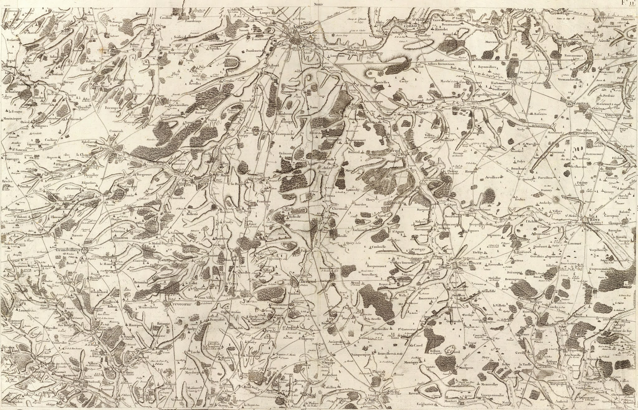
Happily, the internet has opened up cartography, with vast numbers of historic maps and charts being readily available to us all for the very first time. We no longer have to search through library itineraries and order physical maps that, when they turn up may not even be the right ones after all. We can sift through on-line collections and, with a little patience, perseverance and care, find exactly what we need. Finding what you need and turning it into something we can use for a game can still be a complete pain, so I hope that I can save gamers a lot of the leg-work and frustration -after all, I actually enjoy doing this!
As the page title suggests, what I'm attempting to create here is an Atlas of Napoleonic Europe. Not an atlas of the Napoleonic wars. I may at some point add battle maps etc. as I find them, but the idea is to create a kind of RAC atlas of Europe at the turn of the 18th and 19th centuries base on the best period maps I can find. I know there are a lot of players who use modern maps for campaigns, but to me they are so far removed from those of the period that they might as well be using completely imaginary maps. Of course, there is something to be said for using such maps for a historical campaign, but using something that looks and feels right for the game adds something to it for me.
The maps I am including in this Atlas are, where possible, those actually used by various commanders, and, if not, the best possible maps from the Napoleonic period or as short a time before as possible.
The Geographic Institute of Weimar Topographic Military Map of 1807


 |


 |


 |


Karte von Ost-Preussen nebst Preussisch Litthauen und West-Preussen 1796-1802


Lopez' General Map of the Iberian Peninsula 1802


 The 1802 Lopez Regional Spanish Atlas part 1


Nantiat's "New Military Map of Spain and Portugal " of 1810

The four original maps


The sectional maps


Netherlands 1750 by Covens and Mortier

These maps are arranged in a grid 5 sheets wide by 4 deep.


Chorographic Map of the Austrian Low Countries c.1777
OVERVIEW MAP


Sweden and Norway


Russia in Europe


 |
Italy. 1808 Map by Giovanni Antonio Rizzi-Zannoni. for Joseph Bonaparte


 |


The Cassini Atlas of France 1750-1785
These maps by the Cassini family were the best detailed maps of France available during the Napoleonic Wars. I don't know how the family arranged the maps, or how they decided which region to map next, but the result is quite difficult to follow. There is no rhyme or reason to the numbering system adopted and it appears as if they decided at random where they'd like to go next, like butterflies fluttering around.
The plan below shows the location for each sheet. The sheet numbers and titles are listed below this. Sheet numbers can be found along the top edge of each map.
 |
| The Cassini Atlas Index sheet |
Cassini Map Numbers and Titles
1 Paris. 2 Beauvais. 3 Amiens 4 Abbeville 5 St.Omer 6 Dunkerque 7 Fontainbleu
8 Orleans 9 Gien 10 Bourges 11 La Chatre 12 Evaux 13 Aubusson 14 Mauriac
15 Auriac 16 Rodez 17 Albi 18 Castres 19 Carcasonne 20 Montlouis 20b Puigcerda
21 Ambleteuse 22 Boulogne 23 Dieppe 24 Forges.Neufchatel 25 Rouen 26 Evreux,
Dreux 27 Chartres 28 Vendome 29 Blois 30 Loches 31 Le Blanc.Chateauroux
32 Le Dorat 33 Limoges 34 Tulle, Pompadour 35 Sarlet 36 Cahors 37 Montauban
38 Toulouse 39 St Lizier, St Martory 40 Ax 40b Andorre 41 Lille 42 Cambrai
43 Laon, Noyon 44 Soissons 45 Meaux 46 Sens 47 Auxerre 48 Vezelay. Cosne
49 Nevers 50 Moulins 51 Gannat, St Pourcain 52 Clermont 53 Brioud, Issoire
54 St. Flour 55 Mende 56 Nant. Millaud 57 Lodeve 58 Narbonne 59 Perpignan
59b Bellegarde 60 Le Havre 61 Lisieux. Honfleur 62 Argentan, Falaise 63 Alencon
64 Le Mans 65 Tours 66 Richelieu. Saumur 67 Poitiers 68 Charroux 69 Angouleme
70 Perigueux 71 Bergerac 72 Castillonez. Velleneuve 73 Agen 74 Auch 75 Tarbes
76 Luchon. Bareges 77 Rocroi 78 Mezieres 9 Reims 80 Chalons-en-Champagne
81 Troyes 82 Tonnere 83 Semur. Montbard 84 Aubun 85 Chalon-sur-Saon
86 Macon 87 Lyon 88 St Etienne. St Marcellin 89 Le Puy 90 Viviers 91 Nimes
92 Montpellier 93 La Hougue 94 Bayeux, Caen 95 Vire. Avranches 96 Mayenne
97 Laval 98 Angers 99 Mortagne 100 Lucon 101 La Rochelle 102 Saintes 103 Blaye
104 Bordeaux 105 Bazas 106 Roquefort. Mont-de-Marsan 107 Aire. Orthez
108 Pau. Bearn 108b Cauterets 109 Montmedy. Longwy 109b St Hubert 110 Verdun
111 Toul 112 Jounville 113 Langres 114 Dijon 115 Dole. Auxonne
116 Taurnus. Lons-le-Saurnier 117 Bourg-en-Bresse 118 Belley 119 Grenoble
120 Valence 121 Vaison 122 Avignon. Orange 123 Aix 124 Marseille 125 Cherbourg
126 Coutance 127 St Malo. Granville 128 Dinan 129 Rennes 130 Paimbeouf. Redon
131 Nantes 132 La Roche-sur-Yon. Les Sables d'Olonne 133 Ile de Re
134 Ile d'Oloron 135 Cote de Medoc 136 La Teste de Buch 137 Cazau
138 Vieux Boucau 139 Bayonne 140 St Jean Pied de Port 141 Metz
141b Luxenbourg 142 Nancy 143 Mirecourt. Epinal 144 Luxeuil 145 Vesoul
146 Besancon 147 Nozeroy. Les Rousses 148 Geneve. Gex 149 Montmelian
150 Fort Barraux 151 Briancon 152 Embrun 153 Digne 154 Lorgues 155 Toulon
156 Treguier 157 Uzel 158 Vannes 159 Belle Isle 161 Landau. Wiesembourg
162 Strasbourg 163 Colmar 164 Neuf Brisach 165 Bale 166 Queyras 167 Larche
168 Vence 169 Antibes 170St Pol de Leon 171 Carhaix. Brest
172 Quimperle. Quimper 173Philipsbourg 173/5 Audierne. Rade de Brest
174 Ile d'Ouessant 182/169b Tour de Camarat


The Kingdom of Denmark 1796


Britain and Ireland


VIENNA 1778
These maps are of Vienna around 1778, roughly contemporary with the period.


VERSAILLES AND ENVIRONS


No comments:
Post a Comment